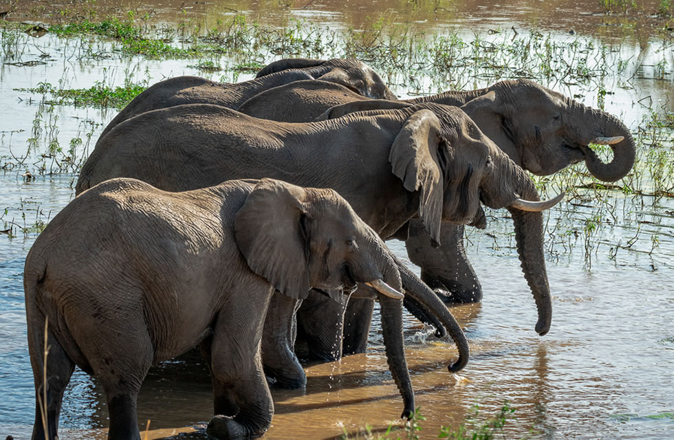
Elephant Tracking in Uganda
Increasing poaching Threat:
Conservationists all over Africa have been seeing an increase in elephant poaching over the past few years. Elephant poaching levels are the worst for a decade and recorded ivory seizures are at their highest level since 1989, according to a report published by the united nations-backed convention on endangered species (CITES). AS RECENT REPORTS IN THE national news papers have highlighted, Uganda has not been spared from the increase in killing of elephants but so ar has suffered less than many other countries in africa. Some areas have lost more than half of their elephant populations in the last five years. Growing demand for ivory in china, coupled with strengthened trade links between china and Africa, is thought to be driving the spiraling ivory trade.
Because of the poaching risk to elephants we have to be careful about including maps and too many details of specific locations in an article such as this. Surprising and sad though it may seem, ivory traders might just read an article in the magazine and get new ideas of where to target elephants that could be poached more easily.
Kidepo, Murchison and queen Elizabeth national parks are the main strongholds for elephants in Uganda wild life authority and the wildlife conservation society with help from kampala aeroclub have fitted satellite collars to elephants in each of these areas.
Kidepo Valley National Park;
In kidepo, elephants were thought to range north across border into the kidepo game reserve and potentially deeper into southern sudan. To get a clear picture of these transboundary movements, six elephants were collared earl in 2008. Since then they have made some brief forays into south sudan and once into Kenya, generally staying within a few kilometers of the boeder and spending the majority of their time in Uganda.
With insecurity in south sudan over the last twenty years; hunting of elephants and other wildlife went unchecked, and only recently have conservation efforts started to re-establish an active ranger force to protect wildlife in the new country’s parks and reserves. Elephants are remarkably good at knowing where they are safe, and this may well be why they spend most of their time in the relative security of the national parks on the Ugandan side of the border.
The satellite tracking data has also shown that elephants use a large area of land south of kidepo, which is now a focus for community based wildlife management. Under such arrangements, local people set aside land and participate actively in the protection of wildlife, and benefit from revenue generated by tourism and sport hunting.
Murchison Falls National Park;
In MFNP a total of nine elephants have been collared (six in 2008 and three in 2010). To the north of Murchison is a historic elephant migration route, along the east side of the Albert Nile, to east Madi wildlife reserve and as far north as South Sudan. One objective was to establish whether elephants still move along this corridor. With the return of peace to northern Uganda, new opportunities have opened up to look for ways of managing this area to keep open these traditional migration routes. The satellite tracking data has shown that a few elephants still move north out of Murchison, but none of the animals we are tracking have made it all the way to East Madi yet. Tracking of elephants in northern Adjumani and across the border into Nimule national park, South Sudan, show that they do come south towards East Madi. So far the tracking data has not shown that they come close to meeting their distant cousins from Murchison, but it is still possible that occasionally they might make that connection. Even an occasional transfer of genes could be important in maintaining the genetic diversity of each population.
Human Conflict
At the same time, with return of peace, people are resettling and starting to farm again in the areas to the north of Murchison. As a result there have been more and more conflicts between people and elephants with elephants raiding crops and an occasion injuring or even killing people. The tracking data allows UWA to better understand the movement patterns of elephants in areas of conflict management efforts, including stationing rangers at key points, where they can ‘scare shoot’ in the air and digging trenches along the park boundary, which can help stop elephants from crossing into community land. A further thing the satellite tracking has shown us however is that elephants can make their way round the end of the existing trench, suggesting perharps it may need extending!
Oil Field Contract
Our tracking data also shows that elephants heavily use the areas of MFNP which are now the focus of oil exploration and exploitation. As oil related activities intensify, the oil componies will have to work very closely with conservation agencies to ensure that disturbance to the elephants and other wildlife is planned and kept to a minimum. A further programme to put more satellite collars on the elephants in this area is being considered as one option to monitor how oil exploration affects their movements. There has been speculation that oil exploration has been chasing elephants out of the park, resulting in more frequent conflicts with the local people. However, our tracking data so far does not provide any identification that that is the case – the elephants which regularly come into conflict with people are those that range around the chobe area on the north east side of the park.
Queen Elizabeth National Park
QENP forms part of an interconnected network of national parks and forest reserves, stretching across the border to the democratic republic of congo (see map). Known as the “great virunga landscape” this complex is one of the most important areas of conservation in Africa, with an incredibly high diversity of plants and animals and many endangered species. As can be seen from the map, many of the protected areas in these network are only connected by narrow corridors of natural habitant. Large bodied and wide ranging animals like elephants rely on these corridors to access different forests, savannahs, lakes and mountains – without them, small populations would be isolated in each protected area, and far less likely to survive. Satellite tracking data of 8 elephants in this landscape showed how they still use many of these corridors. Of particular importance are the routes to the north and south of lake Edward, connecting queen Elizabeth national park to the Parc National des Virungas across the border in DRC and the leading north from Queen Elizabeth to Kibale National Park.
Acknowledgement
The efforts and support of a large number of individuals and organizations have made this elephant satellite tracking project possible and a success. This includes the united states Agency For International Development, MacArthur Foundation, Wildlife Conservation Society, Uganda Wildlife Authority, Kampala Aeroclub and Flight training centre, Dr Patrick Atimned, Jan Broekhuis, Dr mike cock, Geoffrey Mwedde, Dr. Polycarp Mwima, Simon Nampindo, Dr. Andre Plumpture, and many UWA wardens and rangers in QE, Murchison and Kidepo that made up the field teams.